


When tropical meteorologists observe satellite imagesthey often spot subtle cloud formations that suggest something more sinister brewing.
The first signs of a potential hurricane can be detected days before a storm gains strength. Thin cirrus clouds radiating outward, the appearance of curved low-level clouds, and a drop in atmospheric pressure are clues.
These early clues are crucial in predicting the onset of what could develop into a catastrophic hurricane.
I am a meteorology teacher at Penn State, and my research group uses satellites and computer models to improve prediction of tropical weather systems. With an especially violent Atlantic storm season Due in 2024, being able to detect these early signs and provide early warnings is more important than ever. Here’s what meteorologists look for.
Conditions ripe for a hurricane
Hurricanes Typically Start As Atmospheric tropical wavesareas of low pressure associated with clusters of thunderstorms. As these tropical waves move westward across the tropical oceans, some of them may develop into hurricanes.
The formation of a hurricane depends several specific conditions:
Distance from the Equator: Tropical cyclones usually form at least 5 degrees from the equator. This is because the Coriolis forcecrucial for the initial acceleration of the cyclonic system, it is weakest near the equator. The Coriolis force is caused by the Earth’s rotation, which makes moving air go round and round.
Warm sea surface temperatures: The sea surface temperature must be at least 26.5 degrees Celsius (about 80 Fahrenheit) for a hurricane to form. Warm water provides the energy that drives the storm as it absorbs heat and moisture from the ocean.
Atmospheric instability and humidity: For tropical cyclones to form, the atmosphere must be unstable. This means that warm surface air rises and remains warmer than the surrounding air, allowing it to continue rising and forming thunderstorms. There also needs to be a lot of moisture, as dry air can cause clouds to evaporate and weaken upward movements during thunderstorms. These factors are essential for the development of clustered storms within the tropical waves.
Low vertical wind shear: Strong vertical wind shear can destroy a developing hurricane. Vertical wind shear are changes in wind direction or speed at different altitudes. It disrupts the formation and growth of a storm and makes it difficult for a hurricane to keep its vortex aligned.
Forecasting requires more than satellites
Recognizing the early stages of a hurricane’s life cycle has been very challenging because there are not a large number of surface stations and weather balloons to provide detailed atmospheric information over the open ocean.
As soon as a storm begins to form, the National Oceanic and Atmospheric Administration hurricane hunter planes it will often fly through it, taking measurements and discarding sensors to obtain more data. But this cannot happen with all thin clouds, especially when the developing system is far from the coast.
One of the main tools meteorologists currently use to predict early hurricane formation is satellite imagery, which provides real-time data on cloud patterns, sea surface temperatures and other atmospheric conditions. For example, the GOES satellites operated by NOAA help meteorologists track the development of hurricanes with unprecedented clarity. These satellites can capture images at multiple wavelengths, allowing meteorologists to analyze various aspects of the storm, such as cloud formation, precipitation and lightning activity.
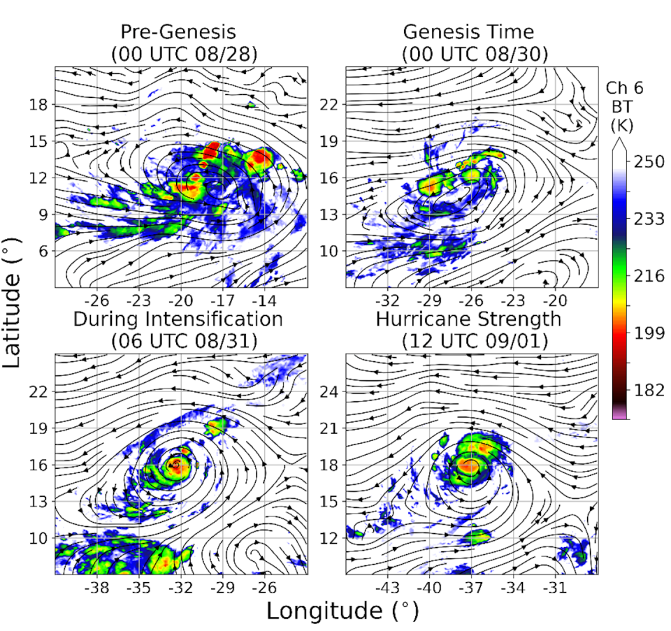
However, satellite observations alone do not provide enough information for meteorologists to know which tropical waves are likely to develop into hurricanes.
To improve forecast accuracy, our research group developed methods for incorporating real-time satellite dataincluding humidity levels and cloud patterns, in computer forecast models. This process, known as data assimilation, allows for a more accurate and consistent representation of atmospheric conditions. As a result, meteorologists can benefit from significantly improved predictive capabilities, particularly in anticipating the formation and progression of hurricanes.
We are currently working with NOAA refine these techniques and make them more widely used for better hurricane forecasting and early warning so that the public has more time to prepare.
As people in North America and the Caribbean prepare for what is expected to be a particularly intense hurricane season in 2024The need for accurate, early storm forecasts has never been greater.
This article was republished from The conversationan independent, nonprofit news organization that brings you trusted facts and analysis to help you understand our complex world. It was written by: Xingchao Chen, State of Pennsylvania
Read more:
Xingchao Chen receives funding from NOAA, DOE, NASA, and ONR.


