


Federal authorities on Monday unveiled a set of tools designed to help protect people in the United States from dangers of extreme heat.
The resources, jointly developed by the National Oceanic and Atmospheric Administration and the Centers for Disease Control and Prevention, include new color-coded heat forecasts and a public dashboard showing local heat risks and air quality levels. New guidelines have also been released for doctorsinstructing them on how to educate patients on how to deal with heat waves and the health impacts of extreme heat.
The tools are part of a broader government initiative to better prepare the country for heat waves, which are increasing in frequency, intensity and duration as a result of climate change. Officials said these efforts aim to raise awareness among those who are particularly vulnerable to extreme heat, including the elderly, pregnant women, people with asthma, young children and individuals with certain underlying health conditions.
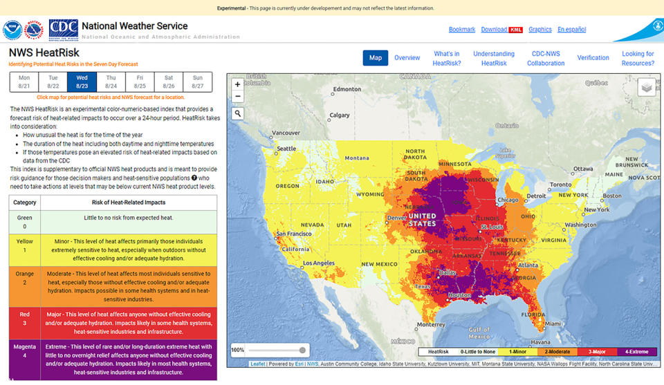
Among the new tools is an experimental NOAA system called “Thermal risk,” which provides a seven-day heat forecast for locations in the contiguous U.S. A numeric, color-coded scale shows users the potential dangers of heat and humidity in their area.
This feature is designed to be used in conjunction with a new dashboard from the Centers for Disease Control and Prevention that allows people to enter their zip code to see real-time and predicted heat risks and air quality information.
Together, the tools and guidelines could, for example, help people identify a place to cool off if they don’t have working air conditioning, recognize symptoms of heat-related illnesses or understand how their medications may interact with heat, said the director of the CDC, Mandy Cohen. she said Monday at a news conference.
“Heat can affect our health, but heat-related illness and death are preventable,” Cohen said.
Heat kills more people in the US each year than any other extreme weather event, including floods, hurricanes and tornadoes. Last year was the the hottest on the planet ever recordedand the summer was brutally hot across large swathes of the US, especially in the South and Southwest.
NOAA officials said they hope the new resources will help communities plan for the upcoming summer months. The agency said it expects temperatures across much of the U.S. in May and June to be above average ahead of what is expected to be another hot summer across the country.
“When it comes to heat, it’s never too early to prepare,” NOAA Administrator Rick Spinrad said at the briefing.
In NOAA’s HeatRisk tool, the scale ranges from 0 or green, meaning little or no risk from expected heat, to 4 or magenta, which indicates extreme and/or long-lasting heat-related impacts.
Risk levels take into account projected high and low temperatures and take into account the cumulative impacts of heat during daytime and nighttime conditions, according to NOAA. Perspectives are designed to be customized by location, as a 100-degree Fahrenheit day in Miami will be different than a 100-degree day in Phoenix, for example.
Forecasts also include historical context to help people understand how unusual projected temperatures will be for any time of year.
Ken Graham, director of NOAA’s National Weather Service, said the tools can help users plan when to limit time outdoors or postpone certain strenuous activities. The idea is to give people more context to complement the heat warnings and advisories the agency issues, he added.
NOAA said the National Weather Service initially developed a prototype of the HeatRisk tool for California in 2013. In 2017, the project was expanded to include all Western states and is now experimentally available in the contiguous U.S.
Members of the public can send comments about the tool to the National Weather Service by September 30.
This article was originally published in NBCNews. with


/cdn.vox-cdn.com/uploads/chorus_asset/file/23954840/acastro_STK061_hulu_01.jpg?w=300&resize=300,300&ssl=1 "Hulu was down for many people, but now it’s fixed")


