


Chasing storms for science can be both exciting and stressful – we knowwhy we do. It was also essential in developing current understanding of how tornadoes form and how they behave.
In 1996, the film “Twister” brought storm-chasing scientists to the public imagination and inspired a generation of atmospheric scientists.
As new “Twisters”As the film hits theaters, we’ve been getting questions about storm chasing – or storm interceptions, as we call them.
Here are some answers about what scientists doing this kind of field work actually do when fleeing after storms.
What is a day of storm chasing really like?
The morning of a chase day starts with a good breakfast as there may not be a chance to have a good meal later in the day. The team analyzes weather conditions, the National Weather Service computational forecast models It is Perspectives from the National Oceanic and Atmospheric Administration’s Storm Prediction Center to determine the target.
Our goal is to discover where tornadoes are most likely to occur that day. Temperature, humidity and winds, and how these change with height above the ground, provide clues.
There’s a “hurry up and wait” cadence to a day of chasing a storm. We want to get into position quickly, but we are often left waiting for storms to develop.
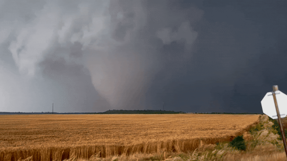
Storms frequently take time to develop before they are able to produce tornadoes. So we watch the storm carefully on radar and with our eyes, if possible, staying well ahead of it until it matures. We will often watch multiple storms and look for signs that one of them may be more likely to spawn tornadoes.
As soon as the mission scientist declares a deployment, everyone scrambles to get into position.
We use many different instruments to track and measure tornadoes, and it’s an art to determine when to deploy them. Too early and the tornado may not form where the instruments are. Too late and we lose. Each instrument needs to be in a specific location in relation to the tornado. Some need to be deployed well in advance of the storm and then remain stationary. Others are mounted on cars and driven back and forth in the storm.
If everything goes well, team members will be focused on the incoming data. launching weather balloons at various distances from the tornado, while others will place “capsules” containing meteorological instruments directly in the path of the tornado.
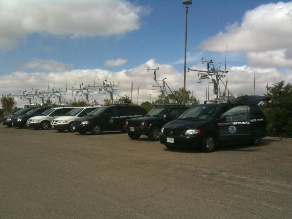
One all network of observation stations will have been deployed during the storm, with radars collecting data from multiple angles, photographers capturing the storm from multiple angles, and instrumented vehicles crossing key areas of the storm.
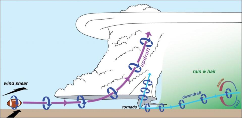
Not all of our work is focused on the tornado itself. We often target areas around the tornado or other parts of the storm to understand how rotation forms. Theories suggest that this rotation may be generated by temperature variations within the storm’s fallout region, potentially many miles from where the tornado forms.
Through it all, the teams stay in touch through text messaging and software that allows us to see everyone’s position in relation to the latest radar images. We are also watching the forecast for the next day so we can plan our next destination and find hotel rooms and hopefully a late dinner.
What do all these instruments say about the storm?
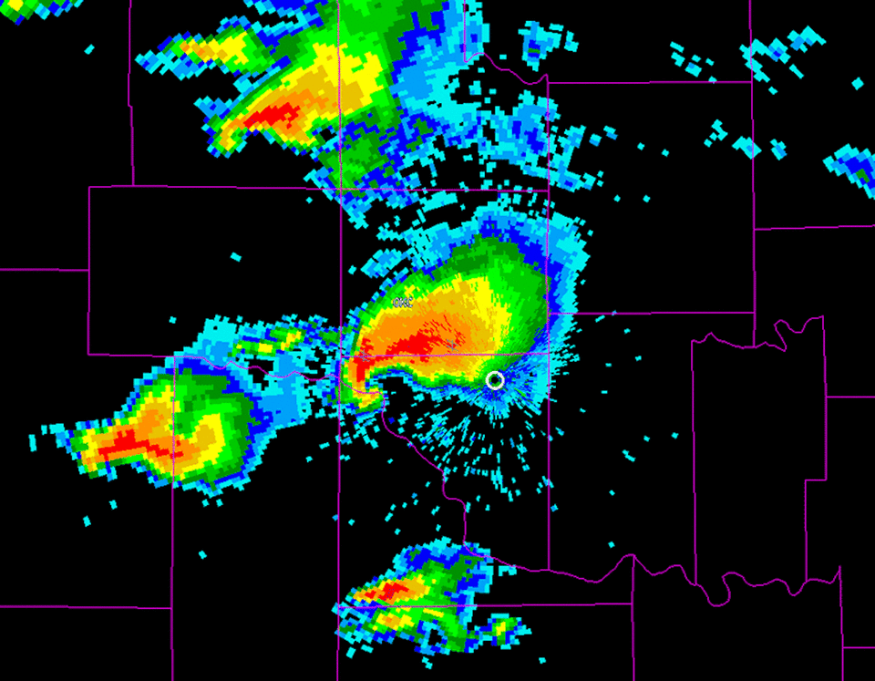
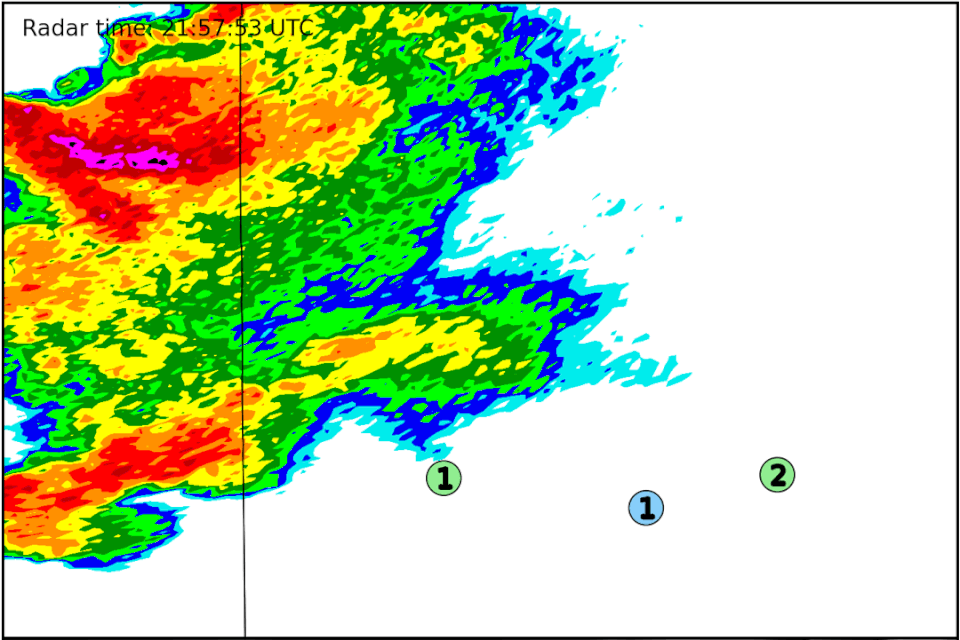
One of the most important tools for chasing storms is weather radar. It captures what’s happening with precipitation and winds above the ground.
We use various types of radars, usually attached to trucks so we can move quickly. Some transmit with a longer wavelength that helps us see further in a storm, but at the cost of a wider beam width, resulting in a fuzzier image. They are good for collecting data throughout the storm.
Shorter wavelength radars cannot penetrate as deeply into precipitation, but they can offer high resolution viewing necessary to capture small-scale phenomena like tornadoes. We place these radars closer to the developing tornado.
We also monitor wind, atmospheric pressure, temperature and humidity along the ground using various instruments attached to moving vehicles, or temporarily deploying stationary arrays of these instruments in advance of the approaching storm. Some of them must be hit by the tornado.
Weather balloons provide crucial data as well. Some are designed to ascend through the atmosphere and capture conditions outside the storm. Others travel through the storm itself, measuring the important temperature variations in the rain-cooled air beneath the storm. Scientists are now using drones in the same way in parts of the storm.
All of this gives scientists insight into the processes that happen during the storm, before and during the development of the tornado, and throughout the life of the tornado.
How do you stay safe while chasing tornadoes?
Storms can be very dangerous and unpredictable, so it is important to always keep an eye on your radar and watch the storm.
A storm may circle, developing a new tornado downstream of the previous one. Tornadoes can change direction, especially when they are dying or when they have a complex structure with multiple funnels. Storm chasers know to watch the entire storm, not just the tornado, and be alert for other storms that may sneak up. An escape plan based on the storm’s expected movement and the road network is essential.
Scientists take calculated risks when chasing storms – enough to collect crucial data, but never putting their teams in too much danger.
It turns out driving is actually the most dangerous part storm chasing, especially when roads are wet and visibility is poor – as is often the case later in the day. During the chase, driving danger may be compounded by erratic driving by other storm chasers and traffic jams around storms.
What happens to all the data you collect while chasing a storm?
It would be nice to have immediate eureka moments, but results take time.
Once we collected the data, we spent years analyzing it. Combining data from all the instruments to get a complete picture of the storm and how it evolved takes time and patience. But having data on wind, temperature, relative humidity and pressure from many different angles and instruments allows us to test theories about how tornadoes develop.
Although the analysis process is slow, the findings are often as exciting as the tornado itself.
This article was republished from The conversation, an independent, nonprofit news organization that brings you trusted facts and analysis to help you understand our complex world. It was written by: Yvette Richardson, Penn State It is Paulo Markowski, Penn State
See more information:
Yvette Richardson receives funding from the National Science Foundation and previously received funding from the National Oceanic and Atmospheric Administration. She is a member of the American Meteorological Society, the National Weather Association, and the American Geophysical Union, and serves on the Board of Trustees of the University Corporation for Atmospheric Research.
Paul Markowski receives funding from the National Science Foundation and previously received funding from the National Oceanic and Atmospheric Administration. He is a member of the American Meteorological Society, the National Weather Association, and is affiliated with the University Corporation for Atmospheric Research.


